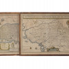
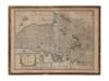
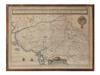
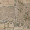
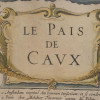
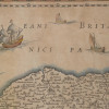
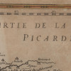
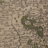
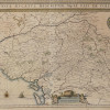
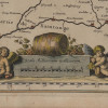
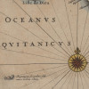
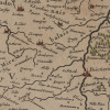
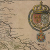
A pair of antique French hand-colored engravings maps. The first is titled, Le Pais De Cavx Normandy Part of Picardy. The Pais or Pays de Caux is a natural region of Normandy belonging to the Paris Basin; inscribed in the print on the lower left; is a printed hand-colored coat of arms with fleur de lis lower left. The second is titled, Pictauiae Ducatus Descriptio Vulgo Le Pais De Poictou, A Description of The Duchy of Poictou, Commonly Known as Le Pais De Poictou, 1638, This map of part of France was published by Joan Blaeu; it appeared in the volume Geographia Blaviana of its eleventh volume Atlas Maior. Joan Blaeu, 1596 to 1673, was a Dutch publisher and engraver; a hand-colored coat of arms upper right. Both framed. Cartographers Historical Map Collection.

.JPG)
.jpg)
.jpg)
.JPG)
.JPG)
.JPG)
.JPG)
.JPG)
.JPG)
.JPG)
.JPG)
.JPG)
.JPG)
.JPG)